wildgoose Simple Map of Europe
wildgoose Simple Map of Europe
Product code: HC1535049
Product Description
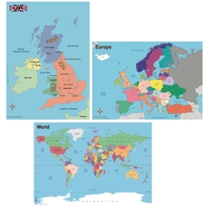
Say Bonjour, Hola, Witam and Ciao to this clear, colourful map of Europe.
Detailing the country borders, capital cities and oceans, it is perfect for any classroom or learning environment. Ideal for delivering key Geography objectives across Key Stage 1 and 2, this map can be used to support study about contrasting localities and to learn about the location of the UK in relation to other countries in Europe.
Atlas! You've found the perfect resource to help your pupils make sense of the world around us and put Geography learning on the map!
What's in the Box?
1 x Map of Europe Size: 594mm x 841mm (A1 size)
- Interactive and colour-coded. This map is perfect for wall displays, as well as for use on a table top with groups of children.
- Essential resource in helping children to ascertain the position of the UK in relation to the rest of Europe.
- Can be used to promote the use of geographical terms and concepts e.g. using compass points and directions.
- Perfect for learning about the different countries in Europe.
- Supports learning about the key physical and human characteristics of European countries.
- Great for support with learning around the geographical similarities and differences of a region of the United Kingdom and a region in a European country.
Further Information
- Age Recommended from
- 5 Years
- Age Recommended to
- 11 Years
- Age Suitability
- 5
- Brand
- Wildgoose Education
- Height
- 594mm
- Key Stage
- Key Stage 1Key Stage 2
- Product Type
- Maps
- Region
- Europe
- Width
- 841mm


